Chasing neutrons: A story that starts in the deep cosmos and ends in a field near you

In the TWIGA proposal, we included one technology that was at the lowest Technology Readiness Level (TRL1). This was a cost-effective detector of environmental neutrons. This blog is a bit technical but, basically, we want to know how wet our soils are, at a scale that is comparable to that observed by satellites. Soil moisture […]
FAO AquaCrop in TWIGA
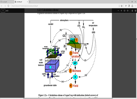
Crop simulation models are widely used by scientists, policy-makers, and practitioners to understand the response of crop yield to variables including soil fertility, water availability, and atmospheric composition. Among crop simulation models a common drawback is the need for highly detailed input data and parameter values, which are rarely available in data-scarce regions such as […]
Water vapor maps from the integration of GNSS measurements, SAR satellite images and NWP models
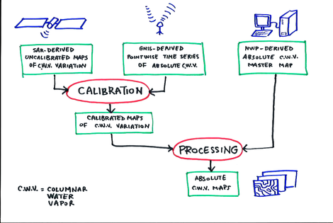
Copernicus Sentinel-1 SAR (Synthetic Aperture Radar) acquisitions allow for the generation of high resolution maps containing the variation of atmospheric water vapor content with respect to a reference situation (MASTER). The maps are in fact the product of a processing technique, known as SAR Interferometry (InSAR), which involves the combination of satellite SAR images acquired […]
TWIGA – HydroNET INTEGRATION
Embracing current and emergent technologies has never been enough in resolving local challenges within our communities. Most often than not, the traditional-silo-kind-of-operation and solution development has proven non-essential in providing a concrete resolve to a given problem. Collaborative approaches however with related models and persons have resulted in refined solutions and more informed techniques of […]
The power of the TWIGA partnership

Within the TWIGA project a broad variety of partners from Europa and Africa are involved. The TWIGA team has applied the award winning HydroNET partnership model where the strength of each partner in the information chain can be optimally used. This blog, written by one of the TWIGA partners HydroLogic Research, outlines the opportunities and […]
ENVIRONMENTAL ACCOUNTING, ON THE DASHBOARD OR IN THE TRUNK?

Fortunately, the attention for environmental accounting and ecosystem accounting is growing. We need more systems for inclusive measurement, monitoring and evaluation. There are many initiatives: On environmental and ecosystem accounting, such as the System of Environmental Economic Accounting (SEEA) (here), The Economics of Ecosystems and Biodiversity (TEEB) (here) and Earth Observation for Ecosystems Accounting (EO4EA) […]
VEGETATION MONITORING (VegMon)

TWIGA acknowledges the important role of vegetation in the hydrological cycle. The vegetation monitoring is being done to monitor growth in the rainy and the dry seasons using an Open Data Kit (ODK) App (VegMon). This therefore entails citizen science – collecting data and analyzing it with farmers and teachers to support agriculture. Selected participants, […]
Towards near real-time atmospheric water vapor monitoring in Africa

Water vapour content of the atmosphere lowest layer (up to about 15 km from the ground), which is known as troposphere or neutral atmosphere, affects GNSS satellite signals propagation velocities, causing delays in their observation from ground-based stations. Based on a proper analysis of such data, one can quantify this delay and therefore have an […]
Field work alternatives during COVID 19

Towards the end of 2019, a good number of students at TU Delft were eager to travel to Africa for TWIGA field work in what we call Q4 (4th quarter, April-June). Unfortunately, as we all know, COVID-19 intervened and made travel all but impossible until now. We had to come up with alternatives to pursue […]
