Copernicus Sentinel-1 SAR (Synthetic Aperture Radar) acquisitions allow for the generation of high resolution maps containing the variation of atmospheric water vapor content with respect to a reference situation (MASTER).
The maps are in fact the product of a processing technique, known as SAR Interferometry (InSAR), which involves the combination of satellite SAR images acquired in two different passes over the same area.
GNSS receivers provide absolute measurements of water vapor content with high temporal resolution. Differently from SAR-derived maps, those pointwise measurements cannot capture the fine-scale spatial variability of water vapor distribution, unless a very dense network of receivers is available.
Nowadays, high resolution numerical weather prediction (NWP) models can enhance their performances by accounting for water vapor observations.
These models however require absolute water vapor values, like the GNSS ones, instead of the differential variations provided by InSAR.
A synergistic use of satellite SAR maps, in situ GNSS time series and NWP models is shown to be the right way to overcome the limits of the two different products.
The GNSS measurements of few receivers included in the SAR imaged area can be used to calibrate the SAR variation maps removing the so-called orbital error.
Water vapor maps, properly derived from NWP models, can be exploited to estimate the MASTER image needed to obtain the absolute high resolution water vapor maps from the calibrated variation maps.
A thorough analysis of the optimal way of deriving the MASTER has been performed within TWIGA using GNSS water vapor products as ground truth.
A detailed description of this work is under publication on Frontiers in Earth Science (here)
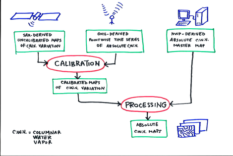
Schematic of the processing chain to derive absolute high-resolution water vapor content maps using SAR images, GNSS time series and NWP model runs.
Edited by Giovanna Venuti, Agostino Meroni and Alessandra Mascitelli
