InfoSequia is now part of the TWIGA portal, a platform that brings together multiple geoclimatic services in Africa

InfoSequia is the Drought Early Warning and Forecasting System developed by FutureWater to support the decision-making and risk management of drought impacts. InfoSequia rests on an advanced cloud computing and geoprocessing architecture able to effectively integrate large volumes of data from satellite, reanalysis, and ground-observation networks, with machine learning techniques to generate local-tailored seasonal outlooks […]
Newly Developed Farm Extension Service Launched: MapYourCrop

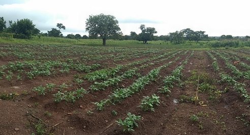
FutureWater, with TWIGA project partners HiView, Hydrologic and UFZ Helmholtz, have developed the farm extension service ‘MapYourCrop’. The MapYourCrop service uses drones, or flying sensors, to collect crop information with an unprecedented level of detail. What makes MapYourCrop unique is that flying sensor data is enriched with detailed crop status information collected by the smartphone […]
Added-value of Flying Sensors: irrigation advice to pineapple farmers

In November 2018, just after the TWIGA days in Kumasi, Ghana, FutureWater, together with partners Hiview and Farmerline, conducted a pilot study using flying sensors (drones) to enhance irrigation water productivity and yields of pineapple farmers. Pineapple is a key economic resource in Ghana, but pineapple yields generally remain low. Yield losses occur due to […]
Flying Sensors, a Catalyst for Revolution in Farming
How can drone technology support our farming activities? This was the question that Kumasi farmers had when they went into the field for a drone workshop. Under the TWIGA Project, a consulting firm from the Netherlands called HiView was contracted by Future Water to deliver training on Flying Sensors to support Farmers’ Decision Making and Flood […]
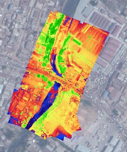
Using drones to get insight into field-scale moisture status
Within the TWIGA project, a student from Wageningen University, Kim Faassen, took up an internship with FutureWater to complete her MSc specialisation Meteorology and Air Quality. We asked Kim to develop a spatial evapotranspiration (ET) product based on a simple method and requiring few data inputs that can be obtained from satellites and drone flights. […]
