Within the TWIGA project, a student from Wageningen University, Kim Faassen, took up an internship with FutureWater to complete her MSc specialisation Meteorology and Air Quality. We asked Kim to develop a spatial evapotranspiration (ET) product based on a simple method and requiring few data inputs that can be obtained from satellites and drone flights. The underlying idea is that this product can be produced quickly in data scarce regions and can be used to inform (smallholder) farmers about the relative moisture status of their field and water use requirements of their crops.
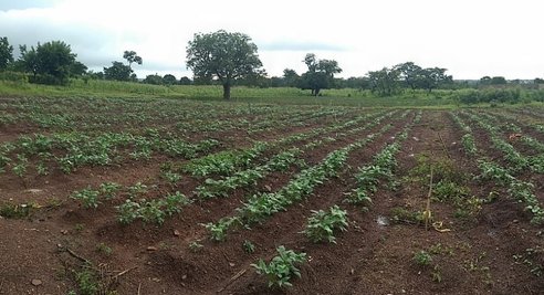
Figure 2 Temperature Vegetation Dryness Index (TVDI) at field scale, derived using satellite and drone input data 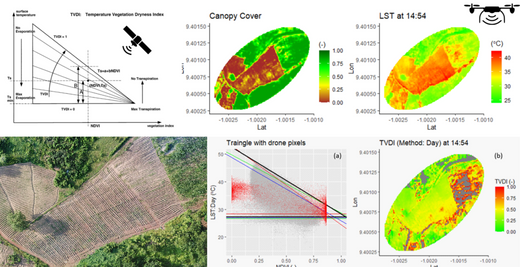
Figure 1 Agricultural field in Nyankpale-Tamale, Ghana
We settled on applying the Triangle Method that uses the Normalized Difference Vegetation Index (NDVI) and Land Surface Temperature (LST), obtained from MODIS satellite imagery, to compute the Temperature Vegetation Dryness Index (TVDI). The TVDI can be a good indication for the spatial variability of the ET, because for a high TVDI (= dry soil) you expect a lower ET and for a low TVDI (=wet soil) you expect a higher ET.
Then, using the shape of the MODIS-derived triangle, in combination with Canopy Cover (CC) and LST maps obtained from drone flights over an agricultural field in Nyankpale Ghana, the TVDI and Evaporative Fraction (EF) was computed at field scale. The EF indicates what fraction of the available energy is used for the ET and thus gives a more direct indication how high the ET is compared to the TVDI.
A rigorous analysis was conducted on how the (satellite derived) TVDI compares to soil moisture products obtained from Sentinel-1 imagery, to get insight and confidence on the applicability of TVDI to indicate the moisture status and ET of this product. It was found that the TVDI performs quite well, but that using the drone images posed some challenges related to data quality and spatial scale mismatches. Despite those challenges, however, we concluded this is a good simple method to get an indication of the spatial variability of the dryness index. The triangle method is a method that uses little amount of data and is therefore applicable in remote areas. The full internship report is available on the website of FutureWater.
TWIGA RELATED SERVICE: MAP YOUR CROP
Written by: Corjan Nolet
FutureWater
