How can drone technology support our farming activities? This was the question that Kumasi farmers had when they went into the field for a drone workshop. Under the TWIGA Project, a consulting firm from the Netherlands called HiView was contracted by Future Water to deliver training on Flying Sensors to support Farmers’ Decision Making and Flood Monitoring. The goal for this training was to support build on and push further on recent advances in sensor and communication technology.
The five days of practice-oriented training were packed with many lessons that many business models can be developed. Can you imagine the speed with which decision-making can be simplified by farmers with technological support? Using flying sensors technologies, a sophisticated camera lens that can distinguish between malnutrition plants and other vegetation, we can eliminate waste of resources such as man-hours in identifying endanger plants, proper usage, and application of fertilizers, water irrigation, and other farming resources which would have gone waste or misused without the flying sensors.
Understanding the technology and its use will have an enormous contribution toward combating many challenges being faced by farmers and the world at large because of food security.
The facilitator, Mr Jan van Til with his patience and expertise took time to explain every detail of flying drone sensors, assembling and disassembling drones, attaching the appropriate camera depending on the objective of flight, and manipulating image data from the camera to produce results and information structure that can help farmers to understand what action to take and what not to take.
Twelve participants benefited from the 5-day training and are expected to develop new services and as well, serve as trainers for the farmers who are eager to adopt new technologies to improve the activities.
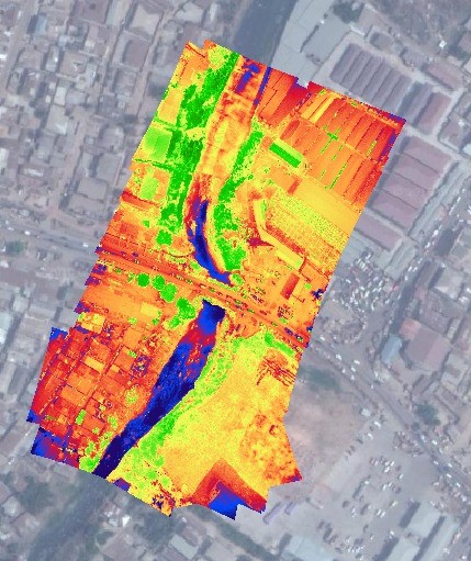
The bottom two images show near-infrared (NIR) and visual capture. All the green areas in the NIR give us a clear indication of good vegetation while the yellows and reds show areas in the image with poor vegetation. With this flying sensor on the farm, the farmer stands the chance of knowing which part of the farm crops that needs attention.

The adoption of this innovative technological solution in farming will go a long way to help to reduce waste of resources such as person-hours on the field, fertilizer, pesticides, and many more. The result is that we can improve yield and address the global issues of food security.
