How water vapour observations enter in the heavy rain phenomena prediction “machinery”.
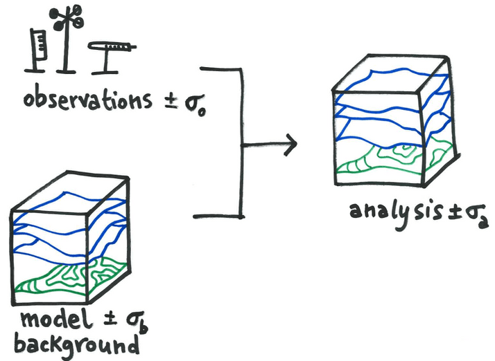
Weather predictions are challenging under many aspects. Nowadays, we have numerical weather prediction models (NWP), which are complex software able to solve mathematical equations by exploiting high-performance computers. The NWP equations describe how some atmospheric variables, like pressure and temperature, change in time and space. By looking at the evolution of those variables in the […]
Water vapor maps from spaceborne radar: first African experiments.
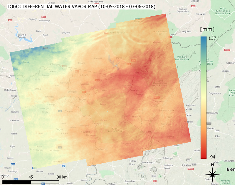
The prediction of rainfall is a critical issue in several African countries. The scarcity of in-situ measurements (for example from ground-based radars) of water vapor content in the lower troposphere prevents Numerical Weather Prediction Models (NWPM) to reach high accuracy in weather forecasts. In order to compensate for the lack of in-situ measurements, satellite images […]
TWIGA experiments for tuning numerical weather prediction models

Within TWIGA, in situ GNSS time series and satellite SAR maps of atmospheric water vapor contents will be used to enhance the predictability of convective storms. This will be achieved by assimilating these products into Numerical Weather Prediction Models (NWP). The Weather and Research Forecasting (WRF) model has been selected to perform the assimilation experiments. […]
How TWIGA will improve heavy rain forecast in Africa

The prediction of heavy rainfall is a critical issue in several countries. In Africa, the scarcity of data to support such predictions makes it fundamental to improve the monitoring of atmospheric parameters. TWIGA researchers will set up a system that exploits satellite images and in-situ measurements to derive useful data for meteorological agencies to improve the prediction of […]
SAR-derived water vapor maps for meteorological applications: processing advancement.

Numerical Weather Prediction Models (NWPM) can significantly benefit from the ingestion of SAR-derived products like water vapor maps. In particular, the contribution of SAR data to NWPM forecasts can be very effective if two conditions are satisfied: the estimated water vapor maps must be ‘dense’ and they must cover wide areas. Water vapor maps are […]
Coping with ionospheric disturbances in sub-Saharan Africa for GNSS meteorological applications

At the end of 2019, TWIGA shipped 6 low-cost GPS stations to Uganda. These were deployed in and around Kampala by Makerere University, with the support of GReD, PoliMi, Makerere University, and TU Delft. The purpose was to derive estimates of tropospheric Zenith Total Delay (ZTD), a parameter useful for meteorological applications. The use of […]
Water vapor maps from the integration of GNSS measurements, SAR satellite images and NWP models
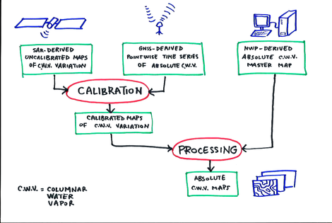
Copernicus Sentinel-1 SAR (Synthetic Aperture Radar) acquisitions allow for the generation of high resolution maps containing the variation of atmospheric water vapor content with respect to a reference situation (MASTER). The maps are in fact the product of a processing technique, known as SAR Interferometry (InSAR), which involves the combination of satellite SAR images acquired […]
