GNSS DEPLOYMENT IN UGANDA

Objective 4 of the TWIGA project aims to Improve predictability and assessment of African rainfall by mapping perceptible water vapour and tracking convective storm systems. The main reason behind the poor prediction skills of present rainfall forecasts in Africa is the lack of knowledge of precipitable water vapour (PWV) in the atmosphere. If one does […]
How water vapour observations enter in the heavy rain phenomena prediction “machinery”.
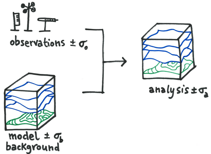
Weather predictions are challenging under many aspects. Nowadays, we have numerical weather prediction models (NWP), which are complex software able to solve mathematical equations by exploiting high-performance computers. The NWP equations describe how some atmospheric variables, like pressure and temperature, change in time and space. By looking at the evolution of those variables in the […]
HOW TWIGA DATA HELPS FARMERS IN KENYA & GHANA

Within TWIGA we work closely with local communities and farmers for which we aim to provide data and model output (information) that can assist them for farming or marketing. Training new farmers and launching our VegMon App in more countries is currently challenging. Yet, with the help of our test users and farmers in Ghana […]
Combining Sentinel-1 and -2 With In-Situ Data to provide Time Series of Soil Moisture Maps at Regional Scale in Ghana

Sub-Saharian African agriculture is perceived as a high-risk activity as is mainly rainfall-dependent and climate variability are increasing. Within the framework of the EU Horizon2020 funded TWIGA project, together Starlab Space and TAHMO intend to contribute to reducing uncertainties related to climatic information by providing improved estimates of surface soil moisture. Accurate risk-related information is […]
HOW COVID-19 IS AFFECTING TAHMO’s WORK IN KENYA

With the global COVID-19 pandemic, activities have been highly slowed down. However, Victor in Kenya is trying to keep things moving. Being a field engineer, it is a bit complicated for him to work from home, but during this pandemic he adjusts and find ways to ensure that field activities do not stop completely especially […]
CO-DESIGN IN TIMES OF COVID-19
One of the few positive points of the Corona-crisis is that it provides an opportunity for reflection. For me, this included looking at the design considerations applied ages ago and the ones we use now. What are the differences and what is still valid? A lesson from the Corona-outbreak is not to take anything for […]
FIRST TWIGA GPS NETWORK DEPLOYED IN UGANDA

TWIGA successfully established the first low-cost GNSS network in Africa, that will be used to continuously measure the amount of water vapor in the atmosphere. This information will allow improving forecasts of extreme weather events, such as cloudbursts and thunderstorms. GPS stations deployed at fixed locations can be used to measure the amount of water […]
TWIGA brings geo-information on weather, water, and climate together in one platform

Climate change results in more extreme weather events with a great influence on water management in our urban and rural environments. The effects of extreme weather are considerable all over the world. Some regions face long-lasting droughts with severe impacts on crop yields. Other regions of the world face excessive rainfall and associated floods. Some […]
Smartphones indispensable tools for flood abatement

Flood events in Kumasi, the second biggest and fastest growing city in Ghana, are becoming more frequent and severe due to changes in the climate and rapid urbanization growth. The natural flood plains are increasingly being used for urban construction. Increasing population also brings along more solid (plastic) waste on the streets and into the […]
