Advances in GNSS meteorology
GPS/GNSS sensors located at fixed positions can be exploited to derive measures of the atmospheric water vapor content with accuracies comparable to conventional instruments. Existing widespread networks of fixed GNSS stations could provide currently unavailable meteorological information to enhance the prediction of heavy rainfall. This innovative potential use of GNSS can be further boosted by the exploitation of low-cost sensors, made available thanks to technological advancements fostered by mass market applications of GPS/GNSS for navigation.
TWIGA allowed for a significant development of meteorological applications of GNSS.
The data collected by a GNSS sensor must be properly processed to calculate water vapor in the column above the sensor. The data must be transferred to a server where, also accounting for the availability of ancillary information, an efficient and robust algorithm must be run to provide timely estimates for the use by meteorologists.
Moreover, dense networks of GNSS receivers are needed to properly monitor the high spatial variability of water vapor distribution. Low-cost sensors represent an affordable solution to both increase the spatial density of existing GNSS networks, designed for geodetic purposes, and to deploy new networks in areas, like sub Saharan Africa, where those receivers are missing.
Within TWIGA, a real time processing service was implemented by the PoliMi spin-off GReD srl and two GNSS networks of low-cost monitoring units were deployed in Uganda and Kenya for meteorological purposes.
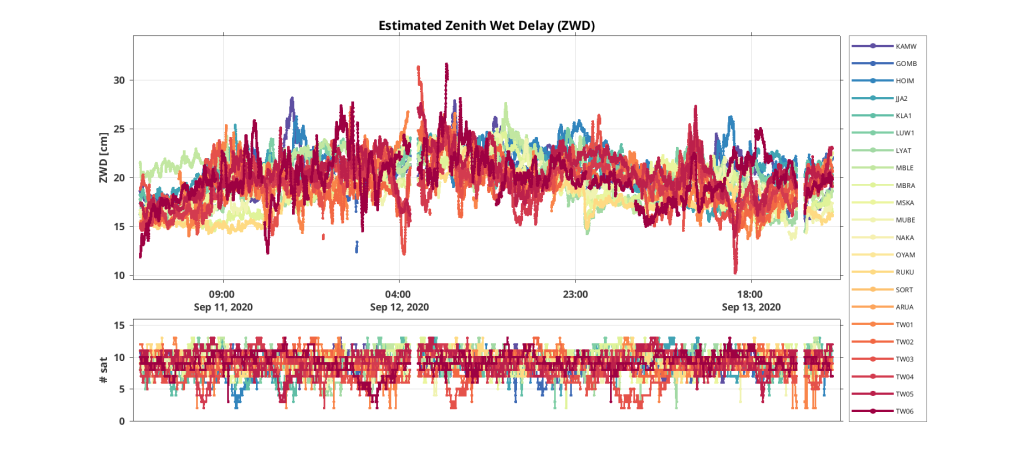
Currently, thanks to this processing service, real time GNSS time series for 11 existing geodetic stations, distributed all over the African continent, are made available through the TWIGA platform. Additionally, post processed water vapor estimates of an existing Ugandan permanent GNSS network are made available to the scientific community through the same platform.
First experiments on GNSS water vapor products assimilation into numerical weather prediction models were performed (see feature on Numerical Weather Predictions).
Graphical abstract

The GNSS low-cost TWIGA network deployed in Uganda

Time series of water vapor products obtained from the pre-existing and experimental low-cost Uganda network data processing

The low cost GNSS monitoring unit deployed at Makerere University, Uganda. The GNSS antenna is the small white dome on top of the pole just behind the solar panel.
Link to services
The assimilation of GNSS water vapor products into NWP models is expected to improve the prediction of heavy rainfalls. The availability of GNSS products will allow for assimilation experiments by the TWIGA meteorological partners, in view of a future operational use of these products to enhance the performances of services based on weather predictions.
Publications
Meroni, A.N., Mascitelli, A., Barindelli, S., Petrushevsky, N., Manzoni, M., Molinari, M.E., Gatti, A., Tagliaferro, G., Lagasio, M., Parodi, A. and Realini, E., 2021, April. Towards the integration of GNSS, SAR and NWP for heavy rainfall forecast in sub-Saharan Africa within the TWIGA project. In EGU General Assembly Conference Abstracts (pp. EGU21-5704).
Mascitelli, A., Meroni, A.N., Barindelli, S., Manzoni, M., Tagliaferro, G., Gatti, A., Realini, E., Venuti, G. and Monti Guarnieri, A., 2020. TWIGA project activities for the enhancement of heavy rainfall predictions in Africa: low-cost GNSS network deployment and NWP model parameterization. (Available on-line https://meetingorganizer.copernicus.org/EGU2020/session/35338)
Venuti, G., Realini, E., Tagliaferro, G., Gatti, A., Barindelli, S., Guarnieri, A.M., Manzoni, M. and Pertusini, L., 2019, January. GNSS and SAR water vapor products for the enhancement of heavy rainfall prediction in Africa: planned activities and preliminary results within the H2020 TWIGA project. In EGU General Assembly Conference Abstracts (p. 16636).
Ssenyunzi, R.C., Oruru, B., D’ujanga, F.M., Realini, E., Barindelli, S., Tagliaferro, G., von Engeln, A. and van de Giesen, N., 2020. Performance of ERA5 data in retrieving Precipitable Water Vapour over East African tropical region. Advances in Space Research, 65(8), pp.1877-1893.
Ssenyunzi, R.C., Oruru, B., D’ujanga, F.M., Realini, E., Barindelli, S., Tagliaferro, G. and van de Giesen, N., 2019. Variability and accuracy of Zenith Total Delay over the East African tropical region. Advances in Space Research, 64(4), pp.900-920.

